When conducting my research, I wanted to give myself a better understanding of what I was going to do. I started to think about mapping, and how this can be used in a way that these residents of the Gaer community could use it adequately. I had a lot to consider, from sensitively from glare of screens too people with dementia will avoid pattered work as is it too confusing for their brain to process the information. These factors made research hard to conduct and a proper investigation into this subject area was needed. I started off by giving myself a better understanding of the people I was going to creating a wayfinding system for. This enabled me to widen my knowledge of design for elderly and with people who have visual impairments.


After reading more into the subject, I was able to give myself a better sense of what was already out there in the design world. I say with my initial idea of using maps, and how I can use them for directing the people of the Gaer community. I started to look at Bristol wayfinding system around their city. These are supposed to be directional, giving everyone who lives in the city access to quick and easy directions. It was good to see how they underwent this project as they were designing for the whole community, which includes people with dementia, and also elderly people as well as all other ages. After giving myself a better understanding of my brief and who I was designing for, I was able to be critical with these design work. I do not think that this wayfinding system will be appropriate for the Gaer community. My reading informed me that people with dementia have trouble with patterns and cluttered areas, and they will easily ignore wat they have seen. Also, the wayfinding system in Bristol is covered in many dark areas. This would not be ideal to use as people who have dementia see dark areas, such as shadows or blocked colours as holes in the ground (or on a board in this case) and will easily lose interest or avoid what they have seen. This gave me a good understanding of what I can try and avoid when starting to tackle the brief of a wayfinding system.

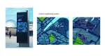
I also looked at other wayfinding systems such as London underground and Norway’s national park Snohetta. These were 2 very good examples to look at before designing my initial ideas. I looked at London underground as it is a beautiful piece of design done by Harry Beck that has been applied across the world. It is great to look at how he has used colourways to give the reader a much easier read and give them a better understanding of a very confusing piece of design. Harry Beck had taken something with great complication and stripped it down to its simplistic form. I thought that this could relate to who I was design for, as I do not want to over confuse these people and give them the best experience I could. The Snohetta wayfinding system is a lot more playful. I included it in my research as I think is a very good ay of attracting people to a particular area and getting them interested in what is in front of them. It shows interest and gives people a point of interest to go to and see what is being offered. This could potentially be applied to the Gaer community.


